California Fire Weather 101
- firelinevalley
- Jan 8
- 5 min read

Updated: May 9
Nocturnal Thunderstorms in Northern California: The Hidden Fire Threat
When we think about thunderstorm season in California, we usually picture hot summer afternoons with towering clouds building over the Sierra Nevada. By evening, we expect things to quiet down as the land cools and the atmosphere stabilizes. But some of the most dangerous fire weather events come from storms that break all the rules—thunderstorms that develop *after dark* over the supposedly storm-proof Central Valley.
Why Nighttime Thunderstorms Shouldn't Happen Here
To understand why nocturnal thunderstorms are so surprising in Northern California, you need to understand what normally keeps the Central Valley storm-free.
During summer months (June through October), the valley's boundary layer—the lowest few thousand feet of atmosphere—is extraordinarily dry. This creates a lid of warm, stable air that parcels of rising air simply can't punch through. Meteorologists call this Convective Inhibition (CIN), and in the Sacramento Valley, it's usually game over for any would-be thunderstorm.
Add to this the normal nighttime cooling. After sunset, the ground radiates heat away, and the lower atmosphere stabilizes even further. With no solar heating to fuel updrafts and an already bone-dry boundary layer, conventional wisdom says thunderstorms are essentially impossible over the valley floor at night.
And yet, they happen.
Elevated Thunderstorms: Breaking the Rules
The key to understanding nocturnal valley thunderstorms lies in a phenomenon called "elevated convection." Unlike typical afternoon storms that are rooted in surface heating and moisture, elevated thunderstorms develop *above* the stable boundary layer, often between 15,000 and 20,000 feet.
These storms don't need the surface to cooperate. Instead, they feed on:
Mid-level moisture transported from the Pacific or monsoon sources
Upper-level lift from passing disturbances, often rotating around offshore low-pressure systems
Layer destabilization as upper-level cooling creates instability aloft
In essence, the storm's "engine" runs entirely in the middle and upper atmosphere. The dry, stable air below is irrelevant—the thunderstorm is decoupled from the surface.
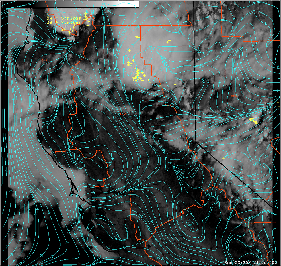
A Case Study: July 21–22, 2002
A well-documented example from the National Weather Service illustrates just how these events unfold.
On the afternoon of July 21, 2002, the Northern Sacramento Valley was sunny and completely storm-free, even as scattered thunderstorms developed over the northern Sierra and Cascades. By early evening, even those mountain storms had fizzled. Any forecaster looking at conditions around sunset would have seen nothing to suggest what was coming.
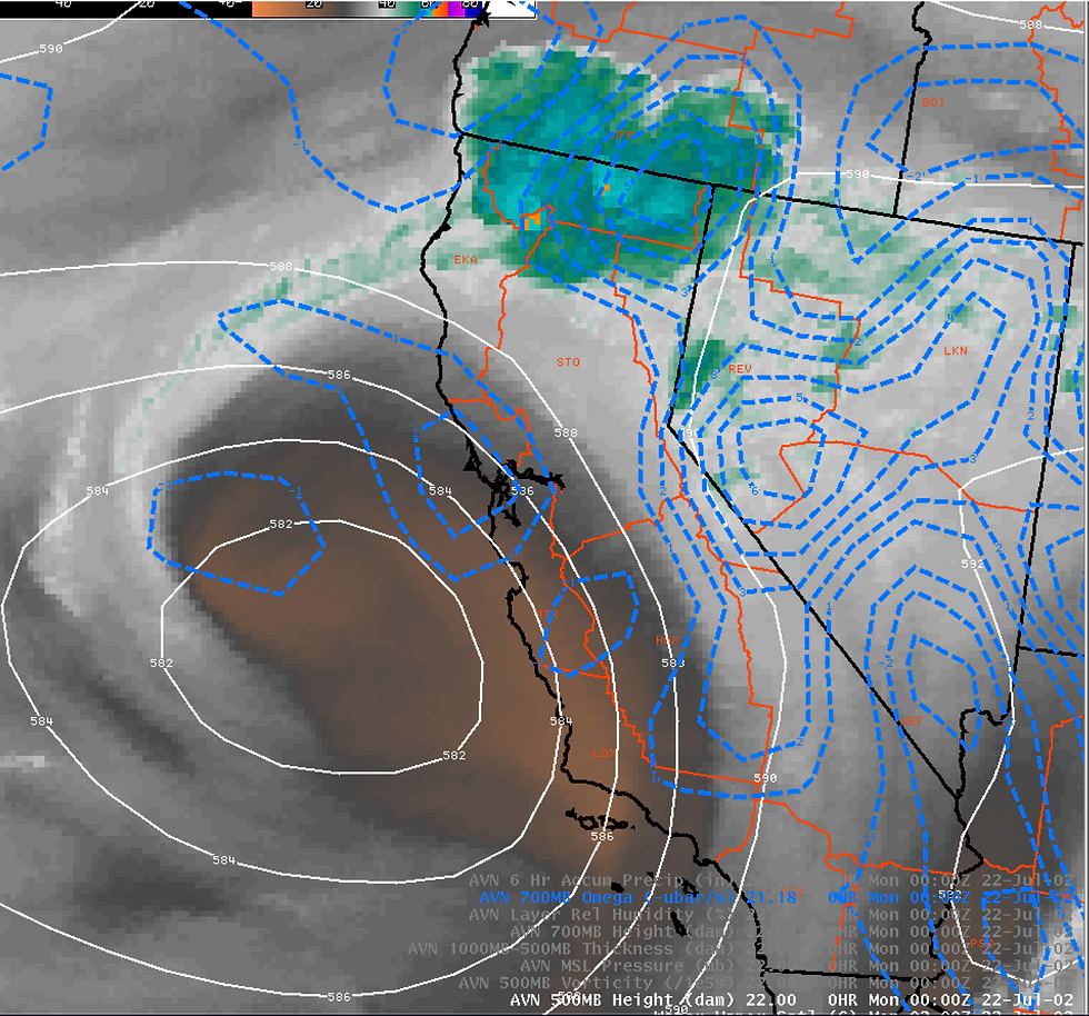
But high in the atmosphere, a different story was unfolding. A weak low-pressure system sat off the Central California coast, and waves of energy were rotating around it. Satellite imagery revealed abundant moisture at mid and upper levels, and model data showed strong upward motion forecast to sweep into the region overnight.
By 9:40 PM local time, thunderstorms began redeveloping—not just over the mountains, but over the flat western Sacramento Valley near Marysville. Over the next few hours, storms proliferated across the northern valley between Red Bluff and Chico, areas with elevations of 200–500 feet above sea level.
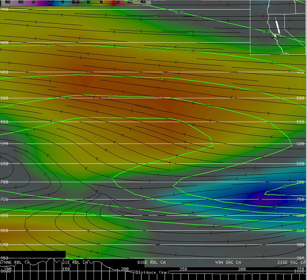
Radar data showed the storms were feeding from southeast winds above 15,000 feet, with the updrafts' source level (the Level of Free Convection) sitting around 583 millibars—roughly 15,000 feet above the valley floor. Analysis showed nearly 1,000 J/kg of Convective Available Potential Energy (CAPE) in that elevated layer, enough to produce strong updrafts despite the stable surface conditions.
Cloud tops plunged below -50°C, and the storms produced numerous cloud-to-ground lightning strikes between 10 PM and midnight.
The Fire Weather Problem
Here's where this matters for fire weather: these storms were *dry*.
The boundary layer remained parched throughout the event. Any rain falling from the elevated thunderstorms largely evaporated before reaching the ground—a phenomenon called virga. What *did* reach the surface was lightning. Lots of it.
This is the nightmare scenario for fire managers:
Lightning without wetting rain can ignite multiple fires simultaneously
Nighttime occurrence means fires may go undetected until morning
Lack of forecaster anticipation means fire resources aren't pre-positioned
Valley and foothill locations put fires in areas with grass and brush primed by summer heat
The 2002 case was relatively modest in its impacts, but the same meteorological setup has produced major fire events. Any situation that puts lightning over dry fuels without significant rain is a recipe for trouble.
Forecasting the Unforecastable
Predicting nocturnal elevated thunderstorms is genuinely difficult. The usual visual cues—afternoon cumulus building into cumulonimbus—don't apply. By the time these storms develop, it's dark, and the mid-level cloud types that might hint at instability (like altocumulus castellanus) are invisible to observers.
Forecasters instead rely on:
Water vapor satellite imagery to track mid-level moisture plumes
High-resolution model forecasts of vertical motion and instability
Analysis of upper-level patterns for approaching impulses and shortwaves
Recognition of synoptic setups like offshore lows with rotating energy waves
The key trigger to watch for is strong upper-level lift interacting with a moist mid-level environment—especially when an offshore or coastal low pressure system is sending disturbances inland.
What This Means for Fire Season
If you're watching fire weather in Northern California, nocturnal thunderstorms deserve a spot on your radar (literally). A few patterns to watch:
Monsoonal moisture surges pushing into NorCal in July–August
Weak cutoff lows setting up off the coast
Model forecasts showing mid-level lift after sunset over the valley
High precipitable water values (the 2002 case had over 1 inch) without corresponding surface moisture
These events don't happen often, but when they do, they can turn a quiet summer night into a multi-fire siege. Understanding the mechanism helps explain why meteorologists sometimes issue Red Flag Warnings that seem to come out of nowhere—because sometimes, the fire weather threat really does develop in the dark.
---
For more on this topic, see the National Weather Service Sacramento's research on elevated thunderstorms and the Northern Sacramento Valley Moisture Convergence Zone.

LFC as is the case with the dry,
‘invertedV'


uppr